
A Milestone in Indo‑U.S. Space Collaboration
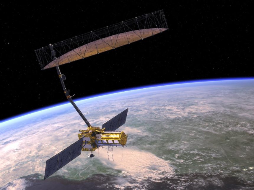
On July 30, 2025, India and the United States successfully launched the NASA‑ISRO Synthetic Aperture Radar (NISAR) satellite—a $1.5 billion mission, jointly developed by ISRO and NASA. Lifted aboard India’s GSLV‑F16 rocket from Sriharikota, NISAR marks the most significant space partnership between the two nations and the first-ever dual-frequency radar imaging satellite.
Dual-Frequency Radar, Unprecedented Precision
NISAR is equipped with two advanced synthetic aperture radars:
- An L‑band radar supplied by NASA
- An S‑band radar built by ISRO
This combination enables it to scan almost all of Earth’s land and ice surfaces every 12 days, detecting ground movements as small as 1 cm, irrespective of weather or daylight.
Climate, Disaster and Earth Surface Monitoring
The satellite’s mission includes tracking:
- Glacial melting and polar ice-sheet dynamics
- Forest biomass, wetlands, and groundwater level changes
- Tectonic shifts, land subsidence, earthquakes, tsunamis, and landslides
Its all-weather radar capabilities aim to improve disaster response, climate data, and environmental monitoring globally.
Technical and Strategic Significance
- NISAR weighs approximately 2,392 kg and orbits at about 743 km in a sun-synchronous path.
- It represents a decade-long effort to create a game‑changing Earth observation platform, reinforcing India’s space ambitions while leveraging NASA’s advanced radar tech.
- The data will be publicly available within days, with critical alerts provided in near‑real time during emergencies.
Immediate Mission Timeline
After launch, NISAR will undergo 90 days of system checkouts and antenna deployments, including a 12‑meter gold‑plated reflector. Scientific operations are slated to begin by October 2025, with a mission lifespan of approximately three to five years.
Global and Scientific Impact
Leaders hailed NISAR as a major step toward democratizing climate and environmental data. NASA officials called it the most sophisticated radar Earth-observation satellite ever flown, while ISRO emphasized its critical role in monitoring climate change, infrastructure risk, and ecosystem transitions.
Final Take
NISAR’s launch heralds a new era in Earth observation and international space cooperation. By combining radar innovation with open-access data, the India‑U.S. mission is poised to transform scientific understanding of natural hazards, climate shifts, and surface dynamics worldwide. This landmark collaboration underscores how space technology can address global challenges and foster strategic partnerships.